The Deep Sea Coral Research and Technology Program has completed one research initiative in the U.S. Pacific Islands region. This initiative ran from 2015 through 2017. It was focused on identifying and mapping locations of deep-sea coral and sponge communities to gain a better understanding of where they would be most at risk from potential new energy development activities. This resulted in exciting findings such as the discovery of new species and dense biodiverse beds of corals, sponges, and other invertebrates living on mineral crusts. Since the initiative, smaller targeted projects in the region are supporting deep-sea coral and sponge conservation efforts.
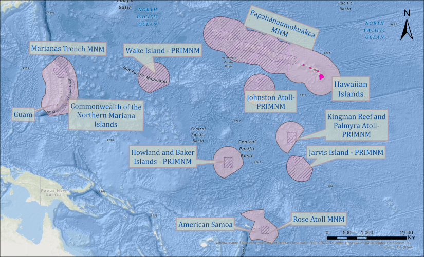
The U.S. Pacific Islands region consists of more than 50 oceanic islands, including the Hawaiian Archipelago, the Commonwealth of the Northern Mariana Islands, and the territories of Guam and American Samoa, as well as the Pacific Remote Islands (Kingman Reef; Palmyra Atoll; Jarvis Island; Howland and Baker Islands; Johnston Atoll; and Wake Island). The U.S. Exclusive Economic Zone of the region includes more than 5.8 million square kilometers (2.2 million square miles) of ocean and is highlighted in pink on the map below. Marine national monuments and other areas of interest are also shown on this map (denoted as purple diagonal lines; abbreviations: MNM - Marine National Monument, PRIMNM - Pacific Remote Islands Marine National Monument)
Volcanic activity in the Pacific Islands region has resulted in a rich seascape of islands, atolls, seamounts, and other geological formations. The steep underwater slopes of these features harbor diverse life, including corals and sponges. For more information on deep-sea corals and sponges in the U.S. Pacific Islands, see Chapter 7 of the Program’s 2017 report: “The State of Deep‐Sea Coral and Sponge Ecosystems of the United States” (PDF, 40 pages).
The U.S. waters of this region are now home to four marine national monuments—Papahānaumokuākea, Marianas Trench, Pacific Remote Islands, and Rose Atoll; along with two national marine sanctuaries—Hawaiian Islands Humpback Whale National Marine Sanctuary and the American Samoa National Marine Sanctuary. These extensive protected areas feature some of the world’s most pristine marine ecosystems. However, scientific knowledge of the species and habitats that lie in the deep waters of the region, including in the monuments, is still limited.
To explore and better understand coral and sponge communities surrounding the U.S. Pacific Islands, particularly within marine national monuments, the Program conducted a fieldwork initiative from 2015 to 2017 in partnership with NOAA Ocean Exploration, the Pacific Islands Fisheries Science Center, the University of Hawaii, and the Western Pacific Regional Fishery Management Council. This larger effort was known as the Campaign to Address Pacific monument Science, Technology, and Ocean NEeds (CAPSTONE). During the initiative, partners completed a staggering 187 remotely operated vehicle dives to depths of up to 6,000 meters (20,000 feet) and mapped more than 635,600 square kilometers (245,400 square miles) of seafloor—or an area nearly the size of Texas. In 2018, the Program also partnered with the Ocean Exploration Trust to conduct the first surveys of a seamount chain included in the 2016 expansion of Papahānaumokuākea Marine National Monument surrounding Hawaii.
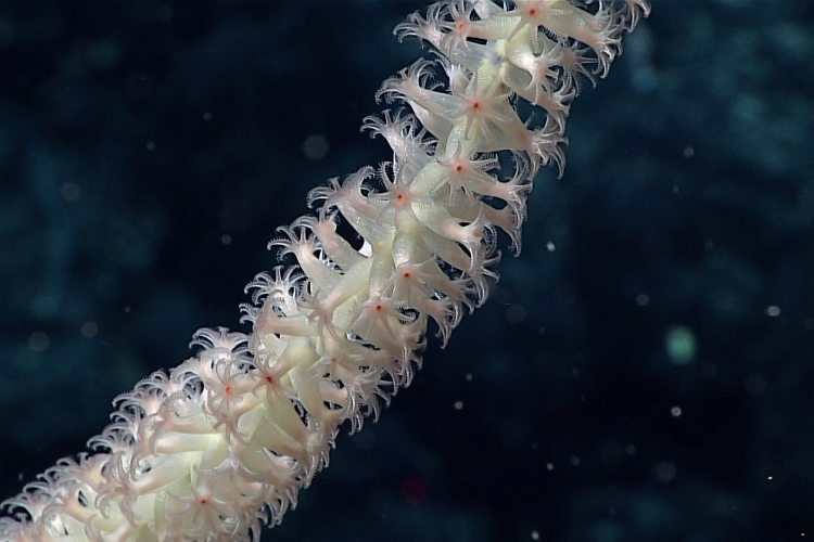
The Pacific Islands are steeped in rich cultural traditions―as inhabitants of remote small islands, the indigenous people have strong ties to the ocean. Hawaii was also home to the only black and precious coral fisheries in the country, although harvests for the last two decades have principally been limited to small amounts of black corals. The natural resources, ecosystems, peoples, cultures, and economy of this area are deeply intertwined, and their health, persistence, and success depend upon each other.
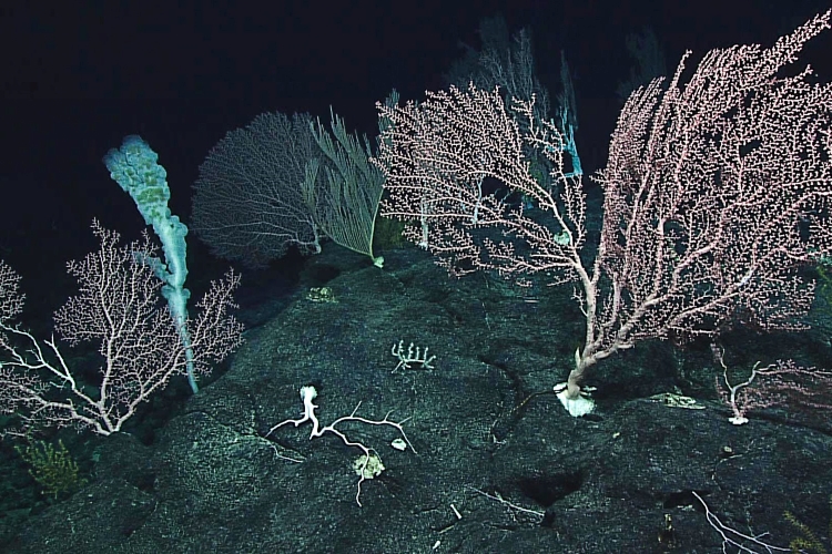
In the 1980s, NOAA and the Western Pacific Regional Fishery Management Council were world leaders in protecting seafloor habitats in U.S. waters around the Pacific Islands from nearly all damaging fishing gear. Today, new industries, including offshore anchored wind energy, aquaculture, and deep-sea mining are exploring opportunities in deeper waters of the region. In recent years, the discovery of large deposits of mineral-rich crusts (which often contain cobalt, nickel, manganese, as well as trace and rare metals) on the central Pacific Ocean seafloor and seamounts has led governments and corporations to take great interest in the region. Because of these economic interests, many of the initiative research questions were focused on identifying deep-sea coral and sponge communities to better understand where they would be most at risk from potential new activities.
Initiative Highlights
Major accomplishments of the initiative include the following:
- Identifying and mapping previously unknown habitats, which revealed a richer biodiversity of coral and sponge species than previously recognized. This included completing the first expeditions to explore these habitats around Wake, Howland, and Baker Islands, Guam, and the Northern Mariana Islands.
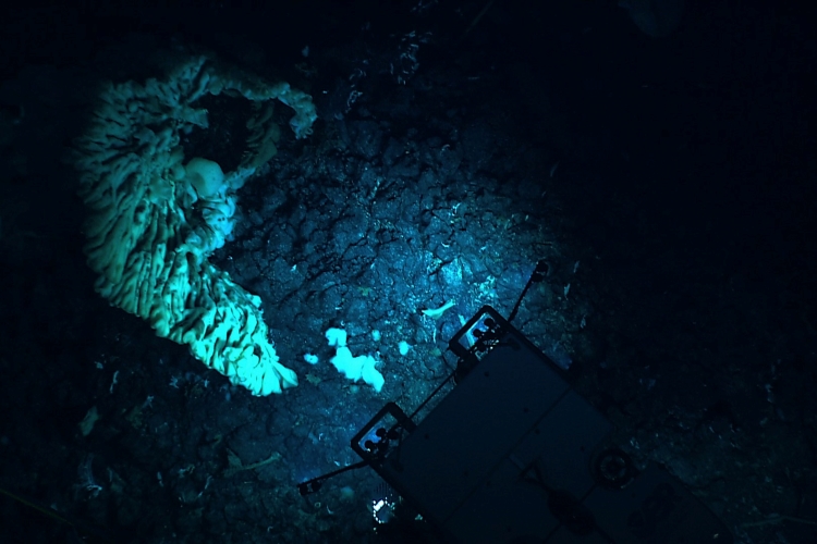
- Collecting nearly 800 biological specimens, which has already resulted in the description of eight new carnivorous sponge species, a new genus and species of glass sponge, four new black corals, a new lace coral, 13 new gorgonian coral species, and the largest sponge ever discovered (see photo below).
- Improving understanding of black and precious coral ecology, which helped the Western Pacific Fishery Management Council refine the identification of Essential Fish Habitat for these potentially-harvested species.
- Engaging more than 260 international scientists, students, and managers in knowledge-sharing, and logging more than 16 million views of CAPSTONE livestreamed remotely operated vehicle video feeds.
- Documenting dense beds of corals, sponges, and other invertebrates living on mineral crusts similar to those that might be targets for future deep-sea mining. Studying these communities within monuments, such as the Papahānaumokuākea Marine National Monument in the Northwestern Hawaiian Islands, can inform strategies for their protection outside U.S. waters where they may be at risk.
Explore below for links to regional protected area websites, workshop reports, science plans, expedition reports, and more.
- Deep Sea Coral Research and Technology Program: Pacific Islands Deep-Sea Coral and Sponge Science Plan (NOAA Fisheries; 2015; PDF, 60 pages)
- Deep-sea Mining Interests and Activities in the Western Pacific (NOAA Ocean Exploration)
- Eyes Below the Surface: Mapping Johnston Atoll (Schmidt Ocean Institute)
- Marianas Trench Marine National Monument (U.S. Fish and Wildlife Service)
- Marine National Monuments in the Pacific (NOAA Fisheries)
- Pacific Islands Benthic Habitat Mapping Center
- Pacific Islands Deep-Sea Coral and Sponge Initiative Final Report (NOAA Fisheries; 2021; PDF, 109 pages)
- Pacific Islands Deep-sea Coral and Sponge 3-year Research Wrap-up Workshop Report (Includes a full list of publications from CAPSTONE work; NOAA Fisheries; 2018; PDF, 36 pages)
- Papahānaumokuākea Marine National Monument (NOAA National Marine Sanctuaries)
- Papahānaumokuākea Marine National Monument Deep Sea Data Portal (University of Hawaii)
- State of Deep‐Sea Coral and Sponge Ecosystems of the U.S. Pacific Islands Region (Chapter 7; NOAA Fisheries; 2017; PDF, 40 pages)
- Tutorial: Explore NOAA's Deep-Sea Coral Database - Coral Observations Recorded in Hawaii (ESRI)
- The Unknown and the Unexplored: Video Highlights of the Pacific Deep Sea Following NOAA CAPSTONE Expeditions (NOAA Ocean Exploration)
-
List of Deep Sea Coral Taxa in the Hawaiian Archipelago and Johnston Atoll: Depth and Geographic Distribution (v. 2021; PDF, 19 pages) - Preliminary List of Deep-Sea Coral Taxa in the American Samoa Region (v. 2021; PDF, 8 pages)
- Preliminary List of Deep-Sea Coral Taxa in the U.S. Mariana Archipelago (v. 2021; PDF, 11 pages)
- Preliminary List of Deep-Sea Coral Taxa in the U.S. Line and Phoenix Island Regions (v. 2021; PDF, 9 pages)
The Pacific Islands Deep-Sea Coral Initiative and CAPSTONE would not have been possible without partnership with NOAA Ocean Exploration, the Pacific Islands Fisheries Science Center, the Western Pacific Regional Fishery Management Council (Council), and the University of Hawaii. Additionally, the Program partnered with the Ocean Exploration Trust to conduct the first surveys of an enigmatic unnamed seamount chain protected under the 2016 expansion of Papahānaumokuākea Marine National Monument. The Council worked closely with the Program to identify management information and data needs, which helped guide the initiative process. In addition to collecting and analyzing data, researchers at the Pacific Islands Fisheries Science Center coordinated the initiative and acted as science advisors during the field expeditions.
University of Hawaii scientists completed almost all video annotations, taxonomic identifications, and summaries of sites explored during the dives. In particular, the Deep-sea Animal Research Center (formerly the Hawaii Undersea Research Laboratory) partnered with the Program to conduct exploratory surveys to monitor the recovery of seamount corals damaged by fishing gear and to assess how deep-sea corals colonize new habitat on lava flows in the western Pacific Ocean. The Program continues to partner with the Deep-sea Animal Research Center to analyze expeditions in the Pacific Islands and other regions of the country.
